Test yourself on River Processes and Landforms with exam style questions, marked instantly.
Flashcards that come back just before you would forget them.
A revision plan that remembers what you know and shows what to do next.
See which topics you have nailed and which need another look.
Quiz yourself on River Processes and LandformsGet your flashcardsBuild my revision planTrack my progress🏞️ The River as a Time Machine
Travel 350 kilometres downstream to Gloucester and the same water — the same River Severn — is almost unrecognisable. Here it moves in great, lazy loops across a perfectly flat floodplain. It is wide and deep, carrying not boulders but invisible particles of fine silt. The valley walls have vanished, replaced by a broad plain of fertile farmland that floods every winter. The river looks almost asleep.
Same river. Same water. Utterly different landscape. The River Severn is a time machine — every kilometre downstream shows you what thousands of years of geological work looks like. From source to sea, erosion gives way to transport gives way to deposition. Understanding that journey is the entire story of this topic.
🔍 The Three Courses: An Overview
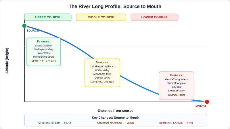
Figure 1: River Long Profile — how gradient, channel shape and dominant processes change from source to mouth
Every river can be divided into three sections — the upper course, middle course and lower course. These are not just geographic zones; they are zones of completely different processes, shaped by the balance between the river's energy and the resistance of the landscape it flows through.
| Feature | Upper Course | Middle Course | Lower Course |
|---|---|---|---|
| Gradient | Steep | Moderate | Gentle |
| Channel | Narrow, shallow | Wider, deeper | Very wide, deep |
| Flow speed | Turbulent (appears fast) | Moderate | Slow but high velocity |
| Dominant process | Vertical erosion | Lateral erosion + transport | Deposition |
| Key landforms | V-valleys, waterfalls, gorges, interlocking spurs | Meanders, river cliffs, point bars, floodplain developing | Meanders, ox-bow lakes, floodplains, levées, deltas |
| Load character | Large, angular boulders | Mixed — cobbles, gravel, sand | Fine silt and clay |
The gradient drops most sharply in the upper course and flattens as the river approaches the sea. This profile — steep at the top, gentle at the bottom — is called the long profile or graded profile. Rivers constantly work towards a smooth, idealised long profile; every landform is a stage in that process.
⚙️ How Rivers Erode: The Four Processes
Erosion is the wearing away and removal of rock and sediment from the river bed and banks. There are four distinct processes, and they often work together simultaneously. Knowing which process causes which effect is essential for exam questions.
1. Hydraulic Action
Hydraulic action is the sheer force of water entering cracks and joints in rock. As water is forced into a crack, it compresses the air inside, increasing pressure. When the water withdraws, that pressure is suddenly released — like repeatedly hitting a wedge into a crack. Over time, rock fragments break off. This process is most powerful where flow is fastest: at waterfalls, in rapids, and where the river narrows. It is the dominant erosion process in the upper course and is responsible for the initial undercutting beneath waterfalls.
2. Abrasion (Corrasion)
Abrasion occurs when the load (sediment and boulders) carried by the river is dragged across the bed and scrapes against the banks, grinding away at the rock surface. Think of it like sandpaper — the river uses its own load as a cutting tool. Abrasion is responsible for the smooth, worn grooves visible on riverbeds in the middle course, and is the main mechanism that creates and deepens potholes — cylindrical holes bored into hard rock by swirling pebbles trapped in depressions on the riverbed.
3. Attrition
Attrition occurs when the load particles themselves collide with each other as they are transported. Each collision chips and breaks the particles into smaller, rounder fragments. This is why downstream sediment looks completely different from upstream boulders: the angular, large rocks of the upper course become the rounded, fine pebbles of the middle course and the smooth, tiny particles of the lower course. Attrition does not remove material from the riverbed — it simply reduces the size and smooths the shape of existing load.
4. Corrosion (Solution)
Corrosion — also called solution — is a chemical process. River water is slightly acidic because it absorbs carbon dioxide from the atmosphere and from soils, forming a weak carbonic acid. This acid slowly dissolves soluble rock such as limestone and chalk, carrying the minerals away in solution. Unlike the other three processes, corrosion leaves no visible physical scar — the rock simply disappears into the water as dissolved ions. In limestone and chalk areas, corrosion can be a major contributor to valley widening and bed lowering.
Quick Check: Which erosion process explains why river pebbles are rounder and smaller downstream than they are at the source?
Attrition. As load particles are transported downstream, they repeatedly collide with each other and with the riverbed. Each collision chips fragments off and smooths the edges, producing smaller, rounder particles. The further downstream, the more collisions have occurred and the rounder and finer the particles become. This is why you find large, angular boulders in upper course streams but smooth, rounded pebbles on lower course riverbanks.
🚛 How Rivers Transport Load: The Four Methods
Transportation is the movement of eroded material (the load) downstream. The type of transport depends on the size of the particle and the velocity (energy) of the river. A river's ability to transport load depends on two properties: its capacity (the total amount of load it can carry) and its competence (the maximum size of particle it can carry). Both increase when velocity increases.
1. Traction
Traction moves the largest, heaviest particles — boulders and cobbles — by rolling them along the riverbed. The particles never leave the bed; they are simply dragged forward by the force of the water. You can sometimes see this happening in a fast-flowing upland stream after heavy rain: large stones visibly rolling and grinding along the bottom.
2. Saltation
Saltation moves medium-sized particles — pebbles and coarse sand — in a hopping or bouncing motion. The current lifts a particle briefly off the bed, carries it a short distance, then drops it. When it lands, it may dislodge another particle, sending it into saltation in turn. This creates a characteristic "bouncing" movement along the bed, visible in shallow upland streams.
3. Suspension
Suspension carries the finest particles — silt and clay — within the body of the flowing water itself. These particles are so light that the turbulence of the flow keeps them permanently lifted off the bed. Suspended load is what makes rivers look brown or cloudy during and after rainfall. It represents the largest proportion of total load carried by most rivers — the River Thames carries millions of tonnes of suspended sediment to the sea each year.
4. Solution
Solution carries dissolved minerals — the products of corrosion — invisibly within the water. There is no visible evidence of this form of transport; the river simply carries dissolved calcium carbonate, sodium chloride and other minerals as ions within the water. Solution transport is particularly important in limestone and chalk catchments.
The Hjulström Curve: Competence and Deposition (Higher Tier)
The Hjulström curve shows the relationship between flow velocity and whether a particle is eroded, transported, or deposited. The key insight is that deposition occurs when velocity drops below a threshold — the river no longer has the competence to carry a particle and drops it. This explains why deposition occurs in three key situations:
- On the inside of meander bends, where flow is slower (deposition builds point bars)
- Where a river enters the sea or a lake, and velocity falls suddenly (deposition builds deltas)
- When floodwater recedes after a flood event (velocity drops, load is deposited across the floodplain)
Interestingly, the Hjulström curve also shows that clay and silt are harder to erode than fine sand, even though they are smaller — this is because clay particles clump together (cohesion) and require a higher velocity to detach them from the bed.
⛓️ How V-Shaped Valleys and Interlocking Spurs Form
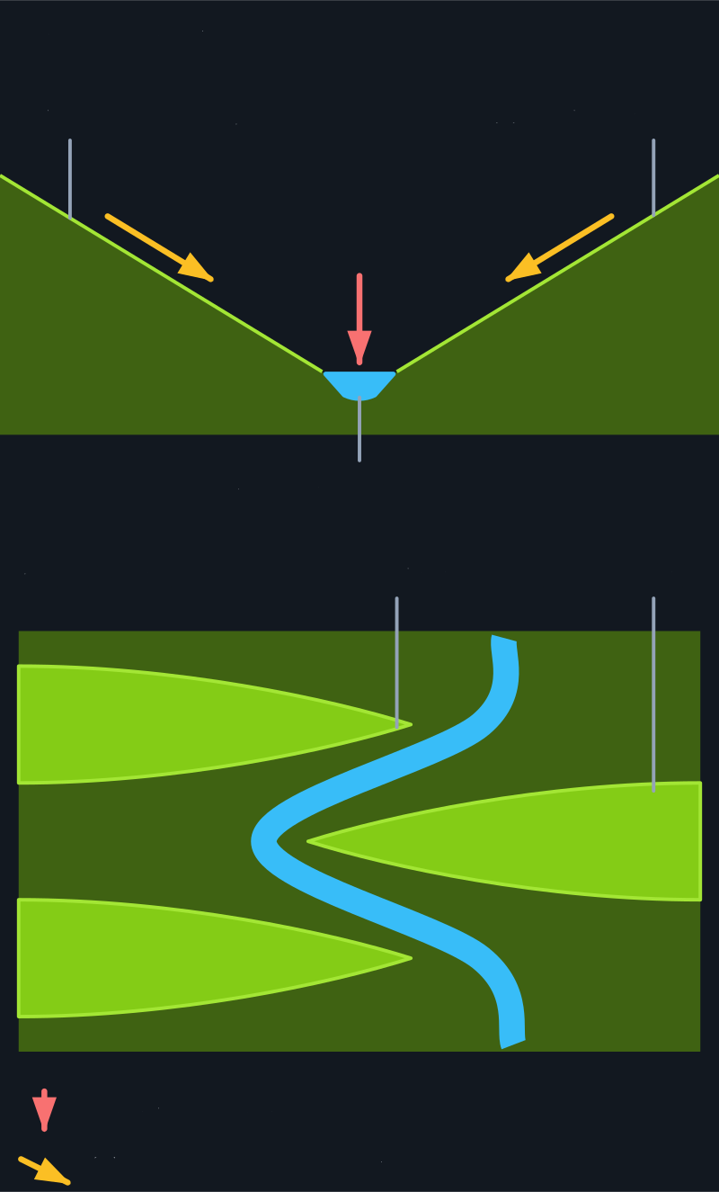
Figure 2: How a V-shaped valley forms. Vertical erosion deepens the channel, then weathering and mass movement widen the sides.
Not to scale. The top picture is a cross-section across the valley. The bottom picture looks down on the valley from above.
V-shaped valleys are the defining landform of the upper course. They are not simply the result of erosion — they form through a specific sequence of interacting processes that must be understood in the correct order for a Level 3 exam answer.
In the upper course, the river descends steeply from high moorland or mountain. This steep gradient converts potential energy into kinetic energy — the water flows fast, with high turbulence, and has great erosive power.
The fast-flowing water uses hydraulic action and abrasion to erode downward into the bedrock. This is called vertical erosion (or downcutting). The river cuts a narrow, steep-sided channel into the landscape.
As the river cuts downward, the rock on either side of the channel is left exposed above the water level. These valley walls are no longer protected by the river — they are exposed to sub-aerial (surface) processes.
Freeze-thaw weathering shatters the exposed rock in the valley walls (water enters joints, freezes, expands by 9%, widens cracks over repeated cycles). Gravity then pulls the loosened material down the slopes through mass movement processes — soil creep, slumping, and rockfalls.
The debris that falls from the valley walls enters the river channel. This adds to the load the river carries, increasing its capacity for abrasion and providing additional material for attrition downstream.
The river cannot always erode in a perfectly straight line — it is deflected by resistant (hard) rock outcrops. It curves around these obstacles, cutting on one side and then the other. The projecting ridges of hard rock that the river winds between are called interlocking spurs — they interlock like the teeth of a zip when viewed from above.
The combination of vertical erosion cutting the floor, weathering and mass movement lowering the walls, and the river weaving between spurs produces the characteristic narrow, V-shaped valley with interlocking spurs typical of upland UK rivers. Named example: River Severn upper course on Plynlimon, mid-Wales; River Swale, Yorkshire Dales.
⛓️ How Waterfalls and Gorges Form

Figure 3: Waterfall Formation — from initial step in hard rock to gorge formation as the waterfall retreats upstream
Waterfalls form wherever a river flows from hard rock onto soft rock — the differential erosion of these two rock types creates a step that becomes progressively more dramatic over time. The formation process is one of the most frequently examined sequences in GCSE Geography.
The river crosses a geological boundary where resistant rock (e.g. hard dolerite, granite) sits immediately above weaker rock (e.g. limestone, shale, sandstone). Initially, a small step or rapid exists where the two rock types meet.
The softer rock beneath erodes much faster than the hard rock above. Hydraulic action and abrasion attack the softer rock at the base of the step, while the hard rock above resists erosion and remains in place. The step gradually becomes more pronounced, then vertical, forming a waterfall.
Erosion of the soft rock continues behind and beneath the waterfall. This forms a rock shelter or cave behind the falling water, and the hard cap rock extends outward as a dangerously unsupported overhang above it. Hydraulic action is most powerful here — water plunges into the cavity and repeatedly compresses and releases the air within cracks in the rock.
Eventually, the overhanging hard rock is unsupported over too great a span and collapses. This collapse is often triggered by freeze-thaw weathering in the joints of the hard cap rock, which progressively weakens it until gravity pulls it down.
The falling water and the collapsed debris both drive abrasion at the base of the waterfall. Boulders are swirled around by turbulent water, acting like a drill, deepening a circular plunge pool. The abrasive action of swirling boulders also smooths the walls of the pool.
With the overhang collapsed, the new face of the waterfall is slightly further upstream than before. The entire process then begins again: undercutting → overhang → collapse → retreat. The waterfall migrates steadily upstream over hundreds and thousands of years.
As the waterfall retreats upstream, it leaves behind a steep-sided, narrow valley called a gorge — the scar of where the waterfall once stood. Over geological time, if the gradient flattens enough, the waterfall may eventually disappear, leaving only the gorge as evidence of its former existence.
Named UK Example: High Force, River Tees, North Pennines
- Location: River Tees, County Durham / North Yorkshire border, North Pennines AONB
- Drop: 21 metres — the largest waterfall in England by volume of water
- Geology: Hard dolerite of the Whin Sill (an intrusive igneous rock) overlies softer limestone and shale
- Gorge: The gorge downstream of High Force is approximately 700 metres long — representing thousands of years of upstream retreat
- Evidence of process: A plunge pool is clearly visible at the base; the cave behind the falls shows active undercutting
- Low Force: 1.5 km downstream, Low Force waterfall sits on the same Whin Sill — a younger, less retreated stage in the same process
Quick Check: Explain why a gorge forms downstream of a retreating waterfall. Use the sequence of formation in your answer.
A gorge forms because as the waterfall retreats upstream, it leaves behind the valley it carved during its retreat. The retreat process — hydraulic action undercutting the softer rock, the hard cap rock overhang collapsing, the waterfall stepping back — occurs over and over. Each cycle moves the waterfall slightly further upstream, abandoning the steep-sided rock face it previously occupied. The accumulated rock faces from each stage of retreat form the walls of the gorge. The gorge is therefore a record of the waterfall's upstream migration — longer gorge = more retreat = longer period of formation. High Force on the River Tees has a gorge approximately 700m long behind it.
⛓️ How Meanders Form

Figure 4: Meander Development and Ox-Bow Lake Formation — from initial deflection to isolated lake
Meanders are the sweeping S-shaped bends that characterise the middle and lower course of most rivers. They are not random — they form through a precise, self-reinforcing process of unequal erosion and deposition that, once started, amplifies itself over time. This is a positive feedback loop, and explaining that mechanism is what separates a Level 2 from a Level 3 answer.
Even a small irregularity — a boulder on the bed, a slightly softer patch of bank, an obstacle from a fallen tree — deflects the main current slightly to one side. This initial deflection is the trigger for the entire meander sequence.
As flow is deflected, centrifugal force pushes the fastest-moving water to the outside of the developing bend. The outside of the bend therefore has higher velocity, higher energy, and greater erosive power than the inside.
The fast-moving water on the outside of the bend drives lateral erosion (sideways cutting) into the bank. Hydraulic action and abrasion undercut the bank from below, eventually causing the bank above to collapse into the river. This creates a steep, near-vertical river cliff on the outside of every meander bend.
A corkscrew-shaped pattern of water movement — called helical flow or secondary circulation — spirals from the outside of the bend to the inside across the riverbed. This flow physically carries the eroded sediment from the outside bank and deposits it on the inside of the bend, where velocity is slower and the river loses its competence.
The slower-moving water on the inside of the bend cannot maintain the same competence as the outside. As velocity drops, load is deposited, building a gentle slope of sediment called a point bar (also called a slip-off slope). Point bars are typically sandy and gravelly — the inside bank of a meander is always shallower and less steep than the outside.
The outside erodes further → the bend becomes more pronounced → the velocity difference between inside and outside increases further → erosion on the outside accelerates → the meander swings wider still. This self-reinforcing cycle means that meanders grow over time, migrating laterally and downstream. The entire valley floor (floodplain) is gradually worked across by the migrating meander, explaining why floodplains are flat and wide.
⛓️ How Ox-Bow Lakes Form
Ox-bow lakes are the dramatic end-point of meander development. They are crescent-shaped lakes that sit isolated beside the river, cut off from the flow that created them. They form when a meander has developed so far that the river takes a shortcut — typically during a flood.
As meander erosion continues over decades and centuries, the loop becomes more and more pronounced. The outside banks are eroded inward; the bend widens. Eventually the meander forms an almost complete circle, with only a narrow strip of land — the meander neck — separating the two sides of the loop.
During a high-energy flood event, the river's velocity is greatly increased. The river has enough energy to break through the meander neck and take the shorter, more direct route downstream. This new course is more efficient — it has a steeper gradient and lower friction.
Once the river has cut through the neck, it preferentially uses this new, more efficient route. The flow through the old meander loop is progressively reduced as more and more water takes the shortcut.
As flow through the old loop decreases, velocity drops and the river deposits alluvium (fine silt) at the entry and exit points of the old meander, sealing it off completely from the main channel.
The old meander loop is now a closed, crescent-shaped body of still water — an ox-bow lake. Over time, the lake slowly fills with sediment and organic matter, eventually becoming a marsh and finally dry land again. At this stage it is visible only as a pale curved arc in the floodplain, called a meander scar. Named UK example: River Great Ouse, Cambridgeshire — multiple ox-bow lakes and meander scars visible in aerial photography of the flat Fenland floodplain.
Quick Check: Why does an ox-bow lake eventually disappear after it forms?
Once an ox-bow lake is sealed off from the main river by deposition of alluvium at its entry and exit points, it becomes a still, enclosed body of water with no throughflow. Over time: (1) fine silt and sediment washed in during flood events settles on the lake floor, gradually reducing its depth; (2) organic material (dead plant matter, leaves) accumulates and adds to the infilling; (3) aquatic plants colonise the shallow margins and further trap sediment; (4) eventually the lake becomes a marsh, then a boggy meadow, and finally dry grassland. The only visible evidence remaining is a meander scar — a slightly curved, lower-lying area of the floodplain that floods more easily than surrounding land.
🌿 Floodplains and Levées
The floodplain is the flat, wide valley floor that flanks the lower course of a river. Far from being a dangerous accident of nature, it is an entirely predictable product of thousands of years of river activity — and one of the most agriculturally productive landscapes in the UK.
How Floodplains Form
Floodplains form by two processes working together over long timescales:
- Lateral meander migration — as meanders erode their outside banks and migrate across the valley, they gradually plane off the valley floor, creating a flat, wide surface. The river works across its own floodplain over centuries, reworking the entire width.
- Overbank flooding and alluvium deposition — when the river overtops its banks during high discharge, it spreads across the floodplain. The sudden drop in velocity causes deposition of alluvium (fine silt and clay). Each flood adds a thin layer of sediment to the floodplain surface. After thousands of floods, a deep, extraordinarily fertile layer of alluvial soil has accumulated. This is why floodplains are prime agricultural land — the Thames Valley, the Vale of York, and the Somerset Levels are all built on flood deposits.
How Levées Form
Levées are natural embankments of sediment that build up alongside the river channel on the floodplain. They form through a selective deposition process during flooding:
As the river floods, it immediately loses velocity as it spreads out across the floodplain — the shallow flood water moves much more slowly than the main channel flow.
The biggest, heaviest particles in the load require the highest velocity to be transported. They are the first to be deposited, immediately beside the channel where the velocity drop is sharpest. This coarse sediment builds up closest to the river.
Very fine particles — silt and clay — remain in suspension even in slow-moving floodwater, and are deposited further from the channel across the wider floodplain.
With each successive flood, more coarse material is deposited alongside the channel. Over time, these natural embankments — levées — can rise 2–5 metres above the surrounding floodplain, raising the river bed above the level of the land on either side. This creates a dangerous situation: if the levée is breached, the flooding is sudden, deep, and extensive because the land behind the levée is lower than the river.
Levées are found beside many UK lower-course rivers, including sections of the River Severn and River Thames. Human engineers often strengthen natural levées with earth embankments and concrete flood walls to improve flood protection.
📊 The Bradshaw Model: How Rivers Change Downstream
The Bradshaw Model summarises all the ways in which a river's characteristics change from source to mouth. It is one of the most important conceptual models in GCSE Physical Geography and is frequently tested with graph interpretation questions.
| Variable | Change Downstream | Reason |
|---|---|---|
| Discharge | Increases | Tributaries add more water to the main channel with each junction |
| Channel width | Increases | More water = greater force pushing outward on banks; lateral erosion widens channel |
| Channel depth | Increases | Greater discharge carves deeper channel; less bedload to obstruct flow |
| Velocity | Increases | Smoother bed = less friction per unit volume of water; deep channel is more efficient |
| Gradient (slope) | Decreases | River approaches base level (sea level); long profile flattens out |
| Sediment size | Decreases | Attrition progressively breaks particles down; finer tributaries add smaller load |
| Sediment roundness | Increases | Attrition progressively smooths and rounds particles |
| Channel roughness | Decreases | Smaller, rounder particles create a smoother, less obstructed channel bed |
| Load quantity | Increases | More tributaries add more material; capacity increases with discharge |
The Velocity Paradox — A Common Exam Trick
Common misconception: "Upper course rivers are faster than lower course rivers because the gradient is steeper." This is wrong.
In reality, lower course rivers typically flow faster than upper course rivers. Here is why: in the upper course, the channel is rough, shallow, and narrow — boulders on the bed create enormous friction, slowing the water despite the steep gradient. In the lower course, the channel is deep, wide, and has a smooth bed of fine silt — friction per unit volume of water is much lower. This is measured by the hydraulic radius (cross-sectional area divided by wetted perimeter): the larger the hydraulic radius, the more efficient the channel and the faster the flow for a given gradient.
Think of it this way: running through deep water on a sandy beach is very slow. Running through deep, clear water in a smooth swimming pool would be much faster. The lower course is more like the pool.
📋 River Tees: A Named UK River Example
The River Tees flows 137 km from its source at Cross Fell (893m) in the North Pennines to its mouth at Teesmouth on the North Sea coast. It is an ideal named example for GCSE because it displays every major fluvial landform within a single river system.
| Course | Location | Key Features | Named Example |
|---|---|---|---|
| Upper course | North Pennines, County Durham moorland | V-shaped valleys, interlocking spurs, waterfalls, gorges, steep gradient | High Force — 21m waterfall on the Whin Sill; 700m gorge downstream |
| Middle course | Cleveland Hills, North Yorkshire | Widening valley, meanders developing, river cliffs and point bars | Barnard Castle section — meanders clearly visible, valley floor widening |
| Lower course | Teesside / Middlesbrough | Wide floodplain, historic ox-bow lakes, levées, industrial development on flat land | Middlesbrough floodplain — flat industrial land built on alluvial deposits; Tees Barrage controls lower river flow |
- Source elevation: 893m (Cross Fell, North Pennines)
- Total length: 137 km
- High Force: Drops 21m; hard Whin Sill dolerite over softer limestone; gorge 700m long
- Whin Sill: Intrusive igneous rock (dolerite) — one of the hardest rocks in northern England, also forms Hadrian's Wall foundation
- Low Force: Second waterfall 1.5km downstream — a younger, less-retreated stage of the same waterfall formation process
- Teesside floodplain: One of the most industrially developed floodplains in the UK — flat alluvial land made it ideal for iron, steel, and chemical industries in the 19th–20th centuries
Quick Check: Why is High Force on the River Tees so much taller (at 21m) than Low Force (about 7m) further downstream, when both waterfalls form on the same Whin Sill rock?
Both waterfalls form where the hard dolerite of the Whin Sill meets the softer limestone/shale beneath. High Force is taller because it has had longer to develop — it formed earlier and has been retreating upstream for longer, allowing more undercutting and overhang formation to occur over a greater vertical height. Low Force is a younger stage of the same process — it has had less time to develop, so the step between the hard and soft rock is smaller. In a sense, Low Force is what High Force looked like thousands of years ago. Both illustrate the same process of differential erosion — just at different stages of development.
⚖️ Comparing the Three Courses
| Feature | Upper Course | Middle Course | Lower Course |
|---|---|---|---|
| Valley shape | V-shaped, steep-sided, narrow | Wider V, valley floor developing | Wide, flat — U or flat-bottomed |
| Main erosion type | Vertical (downward) | Lateral (sideways) | Minimal — mainly deposition |
| Transport methods | Traction, saltation | Saltation, suspension | Suspension, solution |
| Channel shape | Irregular, rocky bed | Smoother, asymmetric at bends | Deep, smooth, very wide |
| Human land use | Moorland, sheep grazing, reservoirs, tourism (waterfalls) | Mixed farming, some settlement, recreation | Intensive agriculture, urban settlement, industry, flood risk management |
| River Tees example | Cross Fell → High Force | Barnard Castle area | Darlington → Middlesbrough |
Common Misconceptions Table
| What many students write | What is actually true |
|---|---|
| "Upper course rivers flow faster because the gradient is steeper" | Lower course rivers are typically faster — smoother bed = less friction = higher velocity despite lower gradient |
| "Erosion only happens in the upper course" | Lateral erosion is the dominant process in the middle course; erosion occurs throughout the river |
| "Meanders form where the river is straight" | Meanders form because an initial irregularity triggers a positive feedback loop of unequal erosion — they require no special conditions |
| "Ox-bow lakes form in the upper course" | Ox-bow lakes form in the middle and lower course, where meanders are well-developed |
| "Levées prevent flooding" | Natural levées can make flooding worse — they raise the river above the floodplain, so a levée breach causes sudden, deep flooding |
| "Abrasion and attrition are the same thing" | Abrasion = load eroding the riverbed; attrition = load particles eroding each other |
📖 Key Terms
- Hydraulic action
- Erosion by the force and pressure of moving water entering cracks in rock, compressing air, and weakening the rock structure
- Abrasion (corrasion)
- Erosion of the bed and banks by the river's own load — particles are dragged across surfaces, wearing them away like sandpaper
- Attrition
- The wearing down of load particles as they collide with each other and with the bed — particles become smaller and rounder downstream
- Corrosion (solution)
- Chemical erosion of soluble rock (especially limestone and chalk) by slightly acidic river water — rock is dissolved and carried away in solution
- Traction
- Transportation of large boulders and cobbles by rolling them along the riverbed
- Saltation
- Transportation of medium-sized pebbles in a bouncing or hopping motion along the riverbed
- Suspension
- Transportation of very fine particles (silt and clay) carried within the body of the flowing water — makes rivers appear brown or cloudy
- Solution
- Transportation of dissolved minerals within the water — invisible, but significant in limestone and chalk catchments
- Discharge
- The volume of water passing a given point in a river per second, measured in cumecs (m³/s) — increases downstream as tributaries add water
- Competence
- The maximum size of particle a river can carry at a given velocity — increases with velocity; when velocity drops, competence drops and deposition occurs
- Capacity
- The total amount (volume) of load a river can carry — increases with discharge
- Meander
- A sinuous (S-shaped) bend in a river formed by unequal erosion on the outside of bends and deposition on the inside
- River cliff
- A steep, near-vertical bank on the outside of a meander bend, formed by lateral erosion undercutting the bank
- Point bar (slip-off slope)
- A gentle slope of deposited sediment on the inside of a meander bend, built up by reduced velocity and helical flow
- Ox-bow lake
- A crescent-shaped lake formed when a highly exaggerated meander is cut off from the main channel, usually during a flood event
- Floodplain
- The flat, wide valley floor flanking the lower course of a river, built up from alluvium deposited by repeated flooding events over thousands of years
- Levée
- A natural embankment of sediment built up alongside the river channel by repeated deposition of coarse material during flood events
- Alluvium
- Fine silt and clay deposited by a river during flooding — builds the floodplain and creates highly fertile agricultural soils
- Interlocking spur
- Projecting ridges of resistant rock in the upper course that the river winds between, creating a zigzag plan view — they interlock like the teeth of a zip
- Plunge pool
- A deep, circular pool at the base of a waterfall formed by the abrasive action of falling water and swirling boulders
- Gorge
- A steep-sided, narrow valley formed in the wake of a retreating waterfall
- Hydraulic radius
- The ratio of cross-sectional area to wetted perimeter — a measure of channel efficiency; higher hydraulic radius = lower friction = faster flow
⚠️ Common Misconceptions
Misconception 1: "Rivers flow faster in the upper course because the gradient is steeper"
This is one of the most common errors in GCSE Geography and catches students out in data response questions. Upper course rivers appear fast — they are turbulent, loud, and visually dramatic — but they are actually flowing more slowly than lower course rivers. The reason is friction. The upper course has a rough, rocky bed covered in large boulders; the river is shallow, meaning a huge proportion of the water is in contact with rough surfaces. This creates enormous friction that slows the water despite the steep gradient. The lower course has a smooth, fine-sediment bed, is deep and wide, and has a very high hydraulic radius — a far greater volume of water is surrounded by a proportionally smaller area of rough channel bed. The result: lower friction, higher velocity, even though the gradient is gentle.
The exam trap: a graph showing velocity increasing downstream looks counterintuitive, but it is correct — and explaining why is a common 3-mark question.
Misconception 2: "Erosion only happens in the upper course"
Erosion is the dominant process in the upper course, but it does not stop there. In the middle course, lateral erosion is the dominant type — rivers erode sideways, widening the valley and cutting into the outside of meander bends. River cliffs in the middle course are evidence of active erosion. Even in the lower course, erosion continues — the river continually undercuts its banks during high discharge events. The difference is simply that in the lower course, deposition generally outpaces erosion, so net sediment accumulation occurs.
Misconception 3: "Abrasion and attrition are the same process"
Both involve wearing away of material, but the target is completely different. Abrasion = the load wears away the riverbed and banks (load is the tool; bed is the material being eroded). Attrition = the load particles wear away each other (the particles are both the tool and the material being eroded — they get progressively smaller and rounder as a result). A useful test: if the question is asking about why sediment is smaller downstream, the answer is attrition. If the question is asking about why the riverbed is being deepened or smoothed, the answer is abrasion.
Misconception 4: "Levées prevent flooding"
Natural levées are not a flood defence — they can actually make flooding more dangerous. Repeated floods build up the levée beside the channel, raising the river bed progressively above the level of the surrounding floodplain. If a levée fails or is breached, the flooding is sudden, deep, and extends far across the floodplain because the land behind the levée is lower than the river. The 2005 New Orleans floods following Hurricane Katrina are a dramatic example of this — the city sits in a bowl behind levées, so when those levées failed, the flooding was catastrophic.
🧠 Memory Aids
RSVP: The Four Transportation Methods (in order, largest to finest)
Rolling (traction — boulders rolling along the bed)
Skipping (saltation — pebbles bouncing along the bed)
Very fine suspension (silt and clay floating within the flow)
Pure solution (dissolved minerals, invisible)
Think of it as a party invitation: the river is RSVP-ing its load from source to sea — from the largest boulders it rolls along the floor to the dissolved minerals it carries invisibly to the ocean.
MOAT: The Four Erosion Processes
Material smashing together (attrition — load particles colliding and breaking apart)
Opening cracks by force (hydraulic action — water pressure shattering rock)
Abrasion — load scraping the bed and banks like sandpaper
Taking dissolved rock (corrosion/solution — chemical dissolution of soluble rock)
A river cuts its valley through the landscape like digging a MOAT — using all four erosion processes working simultaneously.
The Meander Memory Rule: ODES
Outside = fast flow = Erosion (river cliff)
Inside = slow flow = Deposition (point bar)
Spiral (helical) flow transfers material from outside to inside
ODES — Outside Deposits? Erase that! Deposition and Erosion are the other way round! The outside is where the fast water goes → erosion. The inside is where slow water goes → deposition.
Bradshaw Model: The "DVWS" Rule
As you go Downstream from source to mouth:
Discharge and velocity increase
Width and depth increase
Sediment size decreases (smaller, rounder particles)
Slope (gradient) decreases
🎯 Exam Connection
Exam frequency: This topic appears in the vast majority of AQA, Edexcel (1GA0 Paper 1, Component 2) and OCR B Geography papers. River landform formation questions (especially waterfalls, meanders, and ox-bow lakes) are the most commonly examined physical geography processes at GCSE.
Typical Question Types
- "Describe how a waterfall forms" — 4 marks, needs sequenced steps with process names
- "Explain how a meander develops over time" — 6 marks, needs mechanism and positive feedback
- "Use the diagram to explain the formation of an ox-bow lake" — 4 marks, follow the diagram's stages
- "Explain the Bradshaw Model" / "What does the graph show about how [variable] changes downstream?" — 2–4 marks, data response
- "Explain why the lower course of a river has a wide floodplain" — 4 marks, link meander migration + alluvium deposition
- "Suggest why velocity increases downstream despite the gradient decreasing" — 3 marks, friction/hydraulic radius
Level 1 → Level 2 → Level 3: Meander Formation
Level 1 answer (1–2 marks): "Meanders form because of erosion on the outside of the bend and deposition on the inside." — This is correct but purely descriptive. It identifies what happens but not why or how.
Level 2 answer (3–4 marks): "The outside of a meander bend has the fastest flow due to centrifugal force, so lateral erosion undercuts the bank to form a river cliff. On the inside, the flow is slower so the river deposits sediment, forming a point bar. This makes the bend more curved over time." — This explains the mechanism for each side of the bend. It earns marks for connecting velocity to erosion and deposition.
Level 3 answer (5–6 marks): "Meanders form through a self-reinforcing positive feedback loop. An initial irregularity in the channel deflects the main current, shifting maximum velocity to the outside of the developing bend due to centrifugal force. This drives lateral erosion — hydraulic action and abrasion undercut the outside bank to form a river cliff — while helical (corkscrew) flow simultaneously transfers eroded sediment across the bed to the inside, where reduced velocity causes deposition and a point bar builds. The bend becomes more pronounced, which further increases the velocity difference between inside and outside, which accelerates both erosion and deposition, amplifying the meander further still. Over time, the meander migrates both laterally and downstream, sweeping across the entire floodplain. If the neck narrows sufficiently, a flood event can cut through and form an ox-bow lake, leaving a meander scar in the floodplain as the only evidence of the former loop."
The difference between Level 2 and Level 3 is threefold: (1) the mention of positive feedback; (2) naming the specific mechanism — helical flow transferring sediment; (3) linking the meander to a larger consequence — ox-bow lake formation and the floodplain.
→ Before the exam: check River Processes and Landforms: Common Misconceptions — this topic has some of the most commonly confused exam points in GCSE Geography.
💡 Exam Tips
🎯 Common Question Types
- "Describe and explain the formation of [landform]" (4–6 marks) — the most common format. Always sequence your answer: before → during → result.
- "Using the diagram, explain..." (4 marks) — use the diagram's labels and numbered stages to structure your answer; examiners reward use of the provided resource.
- "Explain why [variable] changes downstream" (3–4 marks) — always give a reason (because...), not just a description of what changes.
- "Compare the upper course and lower course" (4 marks) — use comparative language: "whereas", "in contrast to", "unlike". Both sides must be covered for full marks.
- Named example questions: "Using a named UK river..." — always have the River Tees with specific named features (High Force, the Whin Sill, the Teesside floodplain) ready.
📝 Key Command Words
- Describe: Say what you see — features, characteristics, trends. No explanation needed.
- Explain: Give reasons using "because", "therefore", "this means". Causes and mechanisms, not just what happens.
- Use the figure: If it says use the figure, use it — quote data, reference specific features shown, or state what stage is depicted.
- Suggest: Apply your knowledge to an unfamiliar situation — there may be more than one valid answer.
- Compare: Examine similarities AND differences between two things. Never describe one then the other separately — use comparative language throughout.
⚠️ Common Mistakes to Avoid
- Saying erosion processes and transport methods are the same — they are completely separate. Hydraulic action is erosion; traction is transport. Never confuse them.
- Forgetting the plunge pool and gorge when describing waterfall formation — these are two separate mark points that many students miss entirely.
- Describing meanders without mentioning helical (corkscrew) flow — this is the specific mechanism that links outside erosion to inside deposition, and earns a separate mark at Level 3.
- Writing "the river deposits when it slows down" without explaining WHY the river slows down — always state the reason for the velocity change (inside of bend, entering sea, floodwater spreading).
- Confusing abrasion (load wearing the bed) with attrition (load wearing each other) — these earn different marks for different questions. Check which one the question is actually asking about.
- Forgetting to name a specific UK river example when asked — always use River Tees, with at least one specific named feature (e.g., High Force, 21m, Whin Sill).
Make this stick
Signing in gives access to all PrepWise features.