Test yourself on Coastal Processes and Landforms with exam style questions, marked instantly.
Flashcards that come back just before you would forget them.
A revision plan that remembers what you know and shows what to do next.
See which topics you have nailed and which need another look.
Quiz yourself on Coastal Processes and LandformsGet your flashcardsBuild my revision planTrack my progress🌊 The Coast That Is Disappearing
On the Holderness Coast in East Yorkshire, whole villages have vanished. In the village of Skipsea, a farmhouse photographed standing on clifftop ground in the 1990s is now gone — swallowed by the North Sea. Thirty villages that existed at the time of the Domesday Book in 1086 are now underwater. The coastline here retreats by an average of 1.7 metres every year — and after storms, sections can collapse by up to 10 metres in a single night.
The coast is not a passive, stable boundary between land and sea. It is an active battlefield, where waves carrying the energy of thousands of miles of open ocean meet rock and cliffs that have been weakening for centuries. Understanding that battle — the processes, the landforms, and why some coasts retreat while others resist — is the heart of this topic.
🌊 Wave Energy: Where It Comes From and Why It Matters
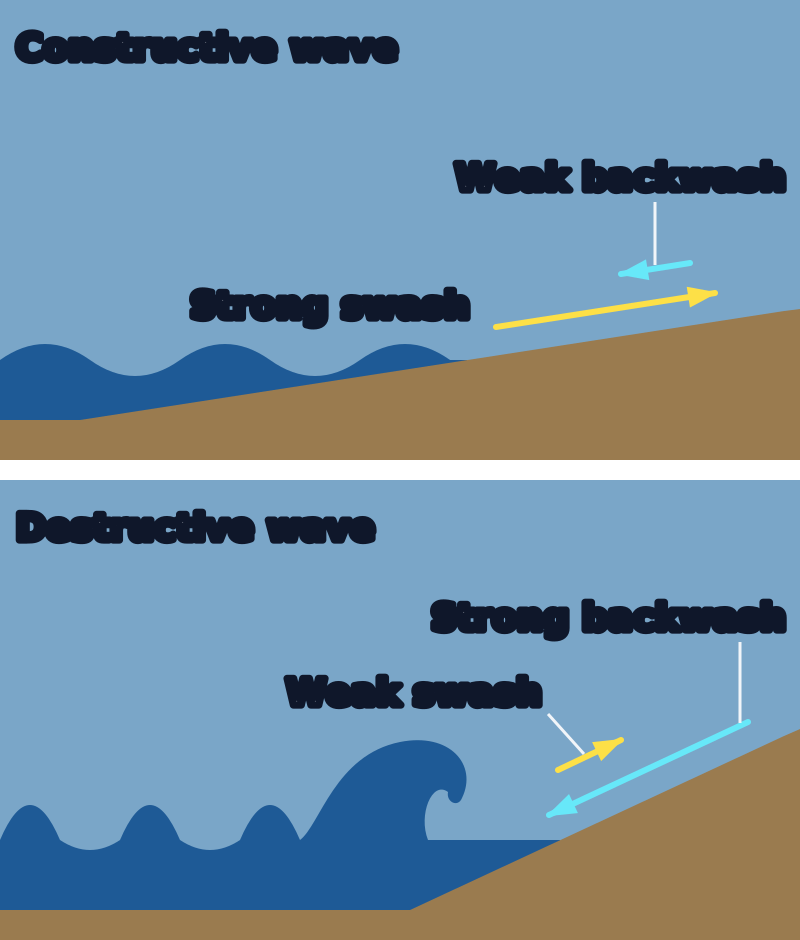
Figure 1: Constructive and destructive waves. A constructive wave has a strong swash and a weak backwash, so it builds up the beach. A destructive wave has a strong backwash and a weak swash, so it wears the beach away.
Constructive waves arrive about 6 to 8 times a minute and destructive waves about 10 to 14 times a minute.
Every wave that crashes against a British cliff started as a tiny ripple hundreds or even thousands of miles away. When wind blows across open water, friction between the air and the water surface transfers energy into the ocean. The water particles begin to move in circular orbits — they don't actually travel with the wave, they rotate in place like wheels turning. It's the energy that moves forward, not the water itself. When that energy eventually reaches the shallow water near the coast, the circular motion is disrupted, the wave slows at its base and topples forward — and everything the wave has stored from hundreds of miles of open ocean is released against the land in a fraction of a second.
The amount of energy in a wave depends primarily on fetch — the distance of open water over which the wind has been blowing. The longer the fetch, the bigger the waves. This explains a striking geographical pattern in the UK: the Atlantic coast of Cornwall and Wales faces winds blowing uninterrupted from North America — a fetch of over 3,000 km. Waves here are enormous and powerful. The English Channel coast of Sussex and Kent has a maximum fetch of a few hundred kilometres. Waves are smaller. The rocks, beaches and landforms of each coast reflect this difference in wave energy — and it is why the wild, dramatic sea stacks of the far north of Scotland look nothing like the gentle shingle beaches of the Solent.
Constructive vs Destructive Waves: The Two Types That Shape Everything
Not all waves behave the same way when they reach the shore, and the distinction between the two main types is one of the most fundamental ideas in coastal geography.
Constructive waves form in calm conditions, often far from the shore. They are long, low, and gentle — imagine a slow rolling swell, not a crashing breaker. Their key characteristic is that their swash (the rush of water up the beach after the wave breaks) is stronger than their backwash (the water draining back down the beach under gravity). The wave deposits more material on the beach than it removes. Think of constructive waves as a gentle push: they nudge sediment up the beach and leave it there, gradually building up the beach profile. These waves break at a frequency of around 6–8 per minute.
Destructive waves form during storms, or when wind has blown hard over a long fetch. They are tall, steep, and crash down onto the beach with tremendous force — like a punch rather than a push. Their backwash is stronger than their swash: water rushes back down the beach pulling sediment seaward before the next wave arrives. Destructive waves have a frequency of 10–14 per minute, meaning the next wave arrives before the previous one has fully retreated — each new wave hits water already flowing back, which increases the chaos and erosive power. These are the waves that eat cliffs.
The beach slope reflects which wave type dominates. Where constructive waves prevail, beaches are wide, gently sloping, and built up. Where destructive waves dominate, beaches are narrow, steep, and constantly being stripped of material. A wide beach is not just aesthetically pleasing — it is a form of natural coastal protection, absorbing wave energy before it can reach the cliff behind.
Quick Check: Explain why the Atlantic coast of Cornwall receives bigger waves than the coast of Kent.
The Atlantic coast of Cornwall has a much longer fetch — the distance of open water over which wind has blown. Winds blowing from North America have over 3,000 km of open ocean to transfer energy into waves before reaching Cornwall. The coast of Kent faces the English Channel, which has a maximum fetch of a few hundred kilometres, so waves have much less energy when they arrive. Longer fetch = more wind energy transferred to the water = bigger, more powerful waves arriving at the coast.
⚙️ The Four Erosion Processes: How Waves Destroy Rock
Waves do not simply "wear the coast away" — that answer will earn you very few marks. There are four distinct erosion processes, each with a different mechanism, and examiners want you to explain the mechanism, not just name it. Use the mnemonic HASA to remember them: Hydraulic action, Abrasion, Solution, Attrition.
When a wave crashes against a cliff, it doesn't just push water against the rock — it traps compressed air in every crack and fissure in the cliff face. For a fraction of a second, that air is squeezed to enormous pressure. Think of it like inflating a balloon inside a sealed box: when the wave retreats, the pressure is suddenly released, and the crack walls are literally ripped apart. Over thousands of wave cycles, even solid rock is gradually fractured, widened, and eventually broken away. Hydraulic action is most effective in rocks that already have fractures or joints — it exploits weaknesses rather than attacking solid rock directly. A single breaking wave can exert up to 30 tonnes of pressure per square metre on a cliff face. That is roughly equivalent to a fully-loaded double-decker bus pressing against every square metre of rock.
Waves do not only carry water — they carry whatever sediment the water has picked up: sand, pebbles, cobbles, sometimes boulders. When waves hurl this sediment against the cliff face and the base of the cliff, the rock fragments act as natural sandpaper, grinding away the surface and literally wearing it down. Abrasion is most effective at the base of a cliff, where repeated wave action creates a wave-cut notch — a horizontal groove at the waterline. It is also responsible for smoothing wave-cut platforms. The harder the sediment being thrown against the cliff, the more effective abrasion is: a wave carrying sharp angular flint fragments is far more destructive than one carrying fine sand.
Seawater is slightly acidic — it contains dissolved carbon dioxide from the atmosphere, which forms weak carbonic acid. This acid reacts chemically with rocks containing calcium carbonate, particularly limestone and chalk. The rock literally dissolves into the water. This is not mechanical wearing — no physical force is needed. It is a chemical reaction that attacks the rock from within, weakening its structure over time. Solution is why chalk cliffs along the South Downs and limestone coasts in Ireland are particularly vulnerable to erosion. It is also why you sometimes see the sea looking slightly milky in these areas — dissolved calcium carbonate in suspension.
Attrition is not a cliff-erosion process — it is what happens to the sediment after it has been eroded. As rock fragments are transported by waves, currents, and longshore drift, they constantly collide with each other and with the seabed. Each collision knocks off corners and chips off edges. Over time, the sediment transforms: angular boulders become rounded cobbles, cobbles become pebbles, pebbles become sand. Pick up a beach pebble and hold it: its smoothness and roundness is the evidence of millions of collisions over thousands of years. Attrition explains why sediment gets finer as you move along a coast in the direction of longshore drift — the particles have simply been travelling longer and wearing down further.
Quick Check: Explain how hydraulic action erodes a cliff. Use the word "pressure" in your answer.
When a wave crashes against a cliff, it traps air inside cracks and fissures in the rock face. The wave compresses this air to very high pressure. When the wave retreats, the pressure is suddenly released — the rapid change in pressure causes the crack walls to be forced apart. Repeated over thousands of wave cycles, the cracks widen and the rock is eventually broken away. Hydraulic action is most effective on rocks with existing joints or fractures, as it exploits weaknesses in the cliff structure.
🏔️ Erosional Landforms: Reading the Story in the Rock

Figure 2: Cave to Stack — the erosion sequence that produces some of Britain's most dramatic coastal scenery
Every cliff, headland, arch and stack tells a story about the processes that shaped it. The key to exam success is being able to tell that story — not just name the landform, but explain the sequence of events that created it.
Wave-Cut Platforms: The Retreating Cliff's Footprint
Stand on the beach at low tide on many British coasts and you will see a wide, flat rocky surface exposed in front of the cliffs. This is a wave-cut platform — and it is the evidence of how far the cliff has retreated. Here is the process as a cause-chain:
Headlands and Bays: Geology Writes the Coastline
Look at a map of the Dorset coast or the Pembrokeshire coast and you will see a deeply indented shoreline — bays tucked between prominent headlands. This pattern is not random. It is written by geology.
Where alternating bands of hard rock (resistant to erosion) and soft rock (easily eroded) meet the coastline at right angles, waves attack the soft rock first and fastest. The soft rock is eroded back to form a bay — broad, shelving, sheltered. The resistant hard rock on either side is left protruding into the sea as a headland. The key exam point is what happens next: once the headland is formed, it sticks out further into the sea than the bays on either side. Waves wrap around it — a process called wave refraction — concentrating their energy on the headland from multiple angles simultaneously. The headland now receives more erosion than the bay, which is somewhat sheltered. The initial difference in rock type is amplified by the shape the coastline has taken.
Caves, Arches, Stacks and Stumps: The Headland's Slow Destruction
A headland is not permanent. Once formed, waves attack any line of weakness — a joint, a bedding plane, a fault — with hydraulic action and abrasion. The sequence that follows produces some of the most dramatic coastal scenery in Britain:
🏖️ Transportation and Depositional Landforms: When the Coast Builds
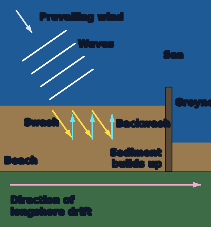
Figure 3: Longshore drift. Waves arrive at an angle, so the swash carries sediment up the beach at an angle and the backwash returns it straight down. Sediment moves along the coast in a zigzag.
A groyne traps sediment on the side the drift comes from, and the beach on the far side is left with less. Here the wind and waves come from the top left, so the drift moves to the right. Not to scale.
Erosion destroys; deposition builds. The material that waves remove from one section of coast is transported elsewhere and eventually deposited where wave energy drops below the threshold needed to keep it moving. The result is a collection of depositional landforms that can appear and disappear on human timescales — far faster than erosional landforms form.
Longshore Drift: The Engine That Drives It All
Most waves do not approach the shore perfectly head-on — they approach at an angle, matching the direction of the prevailing wind. On the east coast of England, the prevailing wind is from the north-east; on the south-west coast of England, it blows from the south-west. This angle of approach governs everything that follows.
When a wave breaks and rushes up the beach — the swash — it pushes sediment up the beach at the same angle as the wave approached. Then gravity takes over: the backwash drains straight back down the beach, perpendicular to the waterline, taking sediment with it. The sediment has moved a short distance along the coast. The next wave does exactly the same. The result is a zigzag movement of sediment along the coast in the direction of the prevailing wind — this is longshore drift.
On the Holderness coast, longshore drift moves sediment southward. Over thousands of years, this material has accumulated at the tip of the headland formed by the chalk wolds — building and rebuilding Spurn Head, the narrow spit that extends 5 km into the mouth of the Humber estuary. Spurn Head is one of Britain's most dynamic landforms: it has been breached by storms, rebuilt, and has migrated westward over centuries as the cliff material feeding it shifts.
Beaches: The Coast's Shock Absorber
A beach forms where wave energy is sufficient to transport sediment but drops enough for deposition to occur — typically in sheltered bays, in areas of lower fetch, or where longshore drift deposits material in calmer water. Constructive waves build beaches; destructive waves strip them. In many parts of the UK, beaches change dramatically between summer (built up by the lower-energy conditions) and winter (stripped back by storms). A beach is not a fixed structure — it is a constantly moving store of sediment.
Spits: Where the Coast Changes Direction
A spit forms where the coastline changes direction — at a river mouth, a bay, or a sudden bend. Longshore drift carries sediment along the coast, but when the land ends and open water begins, there is nothing to support the continued movement of sediment. Instead, material is deposited in the open water, extending outward as a narrow ridge of sand or shingle. The spit grows longer with each wave season.
The curved tip that most spits develop is caused by wave refraction: secondary waves approach the tip of the spit from a different angle to the dominant waves, bending the end of the spit landward. Hurst Castle Spit in Hampshire — extending across the western entrance to the Solent — shows this classic recurved tip. Spurn Head on the Humber demonstrates how spits depend on a constant supply of sediment from updrift erosion: interrupt that supply (as happens when sea walls protect cliffs north of Spurn), and the spit begins to erode and narrow.
Bars and Tombolos
If a spit extends entirely across a bay, cutting it off from the open sea, it becomes a bar — with a lagoon of sheltered water behind it. Slapton Sands in Devon is a classic example, enclosing Slapton Ley. A tombolo forms when a spit or bar connects the mainland to an offshore island — the Isle of Portland in Dorset is connected to the mainland by Chesil Beach, a 29-km shingle tombolo that also forms a bar enclosing the Fleet Lagoon.
Quick Check: Explain how a spit forms. Name a UK example and explain why it has a curved tip.
A spit forms where longshore drift carries sediment along a coast and the coastline changes direction — at a river mouth or a bend in the coast. When the land ends, there is nothing to support the sediment in transit, so it is deposited in open water, extending outward as a narrow ridge of sand or shingle. The spit grows longer over time as more material is added by longshore drift. The curved tip forms because secondary waves approach the end of the spit from a different angle, bending the growing end of the spit back towards the land. Example: Spurn Head (East Yorkshire) extends 5 km into the Humber estuary, formed by southward longshore drift of material eroded from the Holderness cliffs to the north.
⛓️ Why Some Coasts Erode Faster: The Five Factors
Not all coastlines erode at the same rate. Comparing Holderness (losing 1.7 m/year) with the granite cliffs of Land's End (barely changing in recorded history) illustrates that erosion rate is determined by a combination of factors — not just wave energy alone.
This is usually the dominant factor. Hard, resistant rocks such as granite and basalt erode extremely slowly — they are crystalline structures with few cracks to exploit, and they do not dissolve. Softer rocks such as boulder clay, sand and shale erode much faster. Boulder clay — the material that makes up the Holderness cliffs — is a glacial deposit: a mixture of clay, sand and unsorted rock material left by retreating ice sheets. It has no internal structure to hold it together. When it gets wet, it becomes unstable and liable to slump. When waves remove material from the cliff base, the saturated material above simply flows down. Chalk and limestone are chemically vulnerable to solution erosion as well as mechanical attack, making them softer than they appear.
The size and energy of waves arriving at a coast depends on fetch. East-facing coasts in Yorkshire and Lincolnshire face the North Sea — with a fetch of up to 700 km across to Norway. South-west-facing coasts in Cornwall face the North Atlantic — fetch of 3,000 km or more. High-energy waves with long fetches have more power to erode, transport and deposit. The alignment of a stretch of coastline relative to the prevailing wind determines how directly it receives the full force of dominant wave energy.
A wide, deep beach is one of the most effective natural defences a cliff can have. Waves expend much of their energy travelling across a beach before they reach the cliff base — the beach absorbs and dissipates wave energy. Where longshore drift strips sediment from a beach (or human-built groynes and sea walls interrupt sediment supply), the cliff behind is exposed to the full force of waves. The Holderness coast has very little beach in many places precisely because longshore drift removes sediment southward faster than erosion can supply it.
Sea walls, rock armour and groynes can dramatically slow erosion where they are built. But coastal management in one location almost always has knock-on effects. A sea wall reflects wave energy rather than absorbing it — this can scour the beach in front of the wall and increase erosion at its ends. Groynes trap sediment on the updrift side but starve the beach downdrift. Development on cliff tops adds weight and increases the risk of slope failure. In general, human interference with the natural sediment budget tends to shift erosion problems rather than solve them.
Sea level rise — currently approximately 3 mm per year globally, but accelerating — means waves reach further up cliffs and beach sediment is submerged. More frequent and intense storms bring destructive waves more often. In the UK, projections suggest sea levels could rise by up to 1 metre by 2100 under high-emission scenarios. For soft-rock coasts like Holderness, this would significantly accelerate already rapid erosion rates. Climate change does not just threaten future generations — the acceleration is already measurable on vulnerable coastlines now.
📍 Case Study: The Holderness Coast, East Yorkshire
The Holderness Coast is the fastest-eroding coastline in Europe. It stretches for about 60 km from Flamborough Head in the north to Spurn Head in the south, and it is retreating at an average rate of 1.7 metres per year. In severe storms, sections have collapsed by up to 10 metres overnight. Since Roman times, more than 30 villages have disappeared beneath the North Sea — the church towers of some of them are said to be visible on clear, calm days.
Why Is It Eroding So Fast? The Cause-Chain
The Human Cost: Who Is Being Affected?
- The village of Skipsea has lost numerous properties to coastal erosion; some homes have fallen directly onto the beach
- Mappleton was at serious risk by the early 1990s — the B1242 coastal road was just metres from the cliff edge
- Withernsea and Hornsea are larger settlements further south that have historically faced erosion pressure
- Farmland is being lost at the rate of approximately 40 football pitches per year across the coastline
- Gas pipelines, sewage works, and electricity infrastructure within the coastal zone face eventual erosion
- The total economic cost of continued erosion, if unmanaged, is estimated in the tens of millions of pounds over coming decades
The Management Response — and Its Consequences
In 1991, the government invested £2 million in protecting the village of Mappleton. Two rock groynes were built on the beach, and rock armour (large boulders of Norwegian granite) was placed at the cliff base. The protection worked: Mappleton's cliffs have remained essentially stable since 1991. The coastal road was saved.
But protecting Mappleton created a serious problem further south. The rock groynes trapped sediment on the north side of the village — reducing the amount reaching beaches to the south. The cliffs immediately south of Mappleton now receive less sediment protection and face the full force of North Sea waves. Erosion rates south of Mappleton increased after the protection was built. The farm of Great Cowden, south of Mappleton, lost significant land in the years following the Mappleton scheme.
This is the central management dilemma of the Holderness coast — and a critical exam point:
Quick Check: Explain why protecting Mappleton with rock armour increased erosion south of the village.
The rock groynes built at Mappleton trapped sediment on the beach to the north of the village, preventing it from being carried southward by longshore drift. This meant less sediment reached the beaches south of Mappleton. A beach acts as a natural buffer, absorbing wave energy before it reaches the cliff base. With less sediment supply and therefore a smaller beach, the cliffs south of Mappleton were exposed to the full force of North Sea waves. Erosion rates south of Mappleton increased after the protection scheme was built — demonstrating that coastal management in one location can shift erosion problems rather than solve them, and that the sediment budget of the whole coast must be considered, not just individual sections.
⚖️ Erosional vs Depositional Landforms — Side by Side
| Landform | Type | Dominant Process | UK Example | Key Exam Point |
|---|---|---|---|---|
| Wave-cut platform | Erosional | Abrasion + hydraulic action at cliff base | Robin Hood's Bay, Yorkshire | Width shows how far cliff has retreated |
| Headland and bay | Erosional | Differential erosion — soft rock erodes faster | Lulworth Cove, Dorset | Caused by geology, not just wave energy |
| Cave → arch → stack → stump | Erosional | Hydraulic action exploiting joints | Old Harry Rocks, Dorset; Durdle Door | Sequence must be explained in order |
| Beach | Depositional | Constructive waves; longshore drift | Chesil Beach, Dorset | Protects cliff behind; seasonal changes |
| Spit | Depositional | Longshore drift past change in coastline direction | Spurn Head; Hurst Castle Spit | Curved tip due to wave refraction |
| Bar | Depositional | Spit extending across a bay; longshore drift | Slapton Sands, Devon | Encloses a lagoon behind it |
| Tombolo | Depositional | Deposition connecting mainland to island | Chesil Beach / Portland | Can isolate islands from wave energy |
📖 Key Terms
- Fetch
- The distance of open water over which wind has been blowing before it reaches the coast. The longer the fetch, the more energy waves carry when they arrive. The Atlantic coast of the UK has a fetch of over 3,000 km; the English Channel coast has a fetch of a few hundred kilometres.
- Swash
- The rush of water up the beach after a wave breaks. In constructive waves, swash is dominant — it pushes sediment up the beach and deposits it there.
- Backwash
- The flow of water back down the beach under gravity after swash. In destructive waves, backwash is dominant — it pulls sediment back down the beach and out to sea.
- Constructive wave
- A low, long wave with strong swash and weak backwash that deposits sediment on the beach. Frequency: 6–8 waves per minute. Builds up beaches and depositional landforms.
- Destructive wave
- A tall, steep wave with strong backwash and weak swash that removes sediment from the beach and erodes the cliff. Frequency: 10–14 waves per minute. Dominant in stormy, high-fetch conditions.
- Hydraulic action
- Erosion caused when waves trap and compress air in cracks in a cliff face. When the wave retreats, the sudden pressure release forces the crack walls apart. The most effective process at attacking joints and fractures.
- Abrasion (corrasion)
- Erosion caused when waves hurl sediment (sand, pebbles, boulders) against the cliff face, wearing it down like sandpaper. Most effective at the base of cliffs where wave energy concentrates.
- Solution (corrosion)
- Chemical erosion where slightly acidic seawater dissolves calcium carbonate in limestone and chalk rocks. No mechanical force needed — the rock is chemically dissolved.
- Attrition
- The wearing down of sediment particles as they collide with each other and the seabed during transportation. Angular boulders become rounded pebbles, which become sand. Explains why sediment gets finer downdrift.
- Longshore drift
- The zigzag movement of sediment along the coast. Swash carries sediment up the beach at the angle of the prevailing wind; backwash pulls it straight back down under gravity. Net movement is in the direction of the prevailing wind.
- Wave-cut notch
- A horizontal groove eroded at the base of a cliff at the high-tide waterline, cut by hydraulic action and abrasion. When it deepens enough, the cliff above becomes unsupported and collapses.
- Wave-cut platform
- The flat or gently sloping rock surface exposed at low tide in front of a cliff, left behind as the cliff retreats. Its width indicates the extent of cliff retreat over thousands of years.
- Spit
- A narrow ridge of sand or shingle extending from the land into the sea at a change in the direction of the coastline. Formed by longshore drift. Often has a curved tip caused by wave refraction.
- Sediment budget
- The balance between the amount of sediment being added to and removed from a section of coast. Coastal management that prevents erosion upstream reduces the sediment supply to beaches and spits further down the coast.
⚠️ Common Misconceptions
Misconception 1: "Longshore drift is a current flowing out to sea."
Longshore drift does not move sediment offshore — it moves it along the coast. The zigzag movement is entirely along the shoreline: swash up the beach at an angle, backwash straight back down. Each wave cycle nudges sediment a little further in the direction of the prevailing wind. Currents moving offshore are a different phenomenon. Confusing them will cost you marks on any question about spits, beaches or coastal management.
Misconception 2: "Headlands form where waves hit hardest."
Headlands form because of geology, not because waves concentrate on them. It is the other way round: hard and soft rocks erode at different rates, creating the bay-and-headland pattern first. Once the headland is formed and sticks out into the sea, then waves concentrate on it due to wave refraction. The initial cause is differential rock resistance, not selective wave attack.
Misconception 3: "Protecting a coast always helps — it cannot make things worse."
This is wrong and it is exactly the kind of thinking that makes Holderness such a valuable case study. Building a sea wall or groynes at one location interrupts the natural flow of sediment along the coast. Beaches downdrift are starved of their sediment supply. Cliffs that were once protected by a wide beach are now exposed. Spits that depend on sediment input from eroding cliffs begin to shrink. Coastal management in one place can and does cause increased erosion and damage elsewhere — this is called the "sediment budget" problem and it is a Level 3 exam point.
Misconception 4: "Attrition erodes cliffs."
Attrition does not act on cliffs. It acts on sediment particles once they have already been eroded and are being transported. Attrition explains why beach pebbles are smooth and round, and why sediment gets finer as you move along a coast in the direction of longshore drift. The processes that actually erode cliffs are hydraulic action, abrasion and solution — not attrition.
🧠 Memory Frameworks for Coastal Processes
HASA — The Four Erosion Processes
Remember the difference: H, A and S attack cliffs. The second A (Attrition) acts on sediment in transit — it rounds pebbles, not cliffs.
CASE — Factors Affecting Erosion Rate
The Headland Sequence: C — A — S — S
Cave → Arch → Stack → Stump. Each stage in the destruction of a headland begins with hydraulic action exploiting a weakness and ends with the complete collapse and erosion of the remaining structure.
🎯 Exam Connection — GCSE Geography
Paper: examined across all major boards — AQA (Paper 1, Section A: Living with the Physical Environment), Edexcel (Coastal Change and Conflict / Coastal Landscapes and Change), and OCR B (Paper 1 — Our Natural World, Component 1: Distinctive Landscapes).
Exam frequency: Very high on every board — coastal processes and landforms appear in virtually every sitting, typically combining process explanation, landform formation, and Holderness case study material.
Typical Question Types and Marks:
- "Describe and explain the formation of a wave-cut platform." [4 marks] — Requires the notch → overhang → collapse → platform retreat sequence. Two or three linked steps with the processes named (abrasion, hydraulic action). Level 2 requires the mechanism; Level 3 links it to factors that affect how wide the platform grows.
- "Explain one type of coastal erosion." [2 marks] — Name the process AND explain the mechanism. Hydraulic action: name it (1 mark) + explain the air compression and pressure release (1 mark). Naming alone = 0 marks.
- "Explain why the Holderness Coast erodes so quickly." [4–6 marks] — Structure around the CASE factors: soft boulder clay, high-energy North Sea waves, no beach protection. Level 3 requires you to explain HOW each factor contributes, not just list them.
- "Assess the effectiveness of one coastal management strategy." [6–8 marks] — Mappleton rock armour. You need: what was done, what it achieved, the costs (Holderness south), the sediment budget argument, and a supported judgement. Level 3 requires the judgement to be supported with specific evidence.
- "Describe the formation of a spit." [4 marks] — Longshore drift direction, coast change, deposition in open water, curved tip from wave refraction. Name Spurn Head or Hurst Castle Spit.
Moving from Level 1 to Level 3:
- Level 1: "Hydraulic action erodes the cliff." — Names the process but explains nothing.
- Level 2: "Hydraulic action erodes the cliff because waves compress air into cracks." — Explains the mechanism.
- Level 3: "Hydraulic action is particularly effective on the Holderness coast because the boulder clay contains many small fractures and bedding planes — the compressed air can exploit multiple weaknesses simultaneously, which combined with the lack of beach protection means the wave's full energy acts directly on the weakened cliff face." — Mechanism + location + interacting factors.
Command Words for Coastal Questions (used the same way across AQA, Edexcel and OCR B):
- Describe: What does it look like? What features does it have? Use specific geographical terms.
- Explain: Why does it happen? Use "because" — link cause to effect using a process chain.
- Assess / Evaluate: How effective? Consider evidence for AND against; reach a supported judgement.
- Suggest: Use your geographical knowledge to give a plausible reason — no single correct answer.
Best evidence to deploy in any answer: HASA for erosion; Holderness 1.7 m/year; Mappleton protection scheme + sediment budget consequence; Spurn Head for longshore drift; Durdle Door or Old Harry Rocks for cave-arch-stack; boulder clay vs granite contrast for rock type.
💡 Exam Tips for Coastal Processes and Landforms
🎯 Common Question Types:
- "Explain how one erosion process shapes the coast" [2–4 marks] — Name + mechanism (NOT just definition)
- "Describe and explain the formation of a headland and bay / wave-cut platform / spit" [4 marks] — Use a cause-chain, name UK examples
- "Explain why some coasts erode faster than others" [4–6 marks] — CASE framework; compare rock types with named examples
- "Evaluate the success of coastal management at a named location" [6–8 marks] — Mappleton; positive + negative; sediment budget; supported judgement
📝 Key Command Words in Coastal Questions:
- Define: Give the correct geographical meaning in one sentence
- Describe: State what you observe — features, patterns, characteristics
- Explain: Give a reason — "because" is essential; link the process step by step
- Assess: Make a judgement with evidence — consider both sides, reach a conclusion
⚠️ Common Mistakes to Avoid:
- Saying the cliff "wears away" without naming a specific process — always use HASA terminology
- Confusing attrition (rounds sediment particles) with abrasion (erodes cliffs) — they are different things
- Writing that headlands form where waves are strongest — geology causes headlands, not wave concentration
- Forgetting to name UK examples — "a headland" scores less than "Old Harry Rocks in Dorset"
- Treating the coast as a single strip — remember sediment budget links protection in one place to erosion elsewhere
- For management questions: only writing about the benefits — always assess the costs and the impacts downdrift
Quick Check: Write a Level 3 answer explaining why the Holderness Coast erodes so quickly. Include at least two specific factors and how they interact.
Example Level 3 answer: "The Holderness Coast erodes at approximately 1.7 metres per year — the fastest rate in Europe — because multiple reinforcing factors combine to create exceptional vulnerability. The cliffs are made of boulder clay, a soft glacial deposit with no internal cementation that becomes unstable when saturated and offers minimal resistance to wave attack. This soft geology is exposed to high-energy destructive waves generated by a fetch of up to 700 km across the North Sea, meaning waves arrive with significant erosive power. Crucially, the coast has very little beach protection: longshore drift removes sediment southward at around 500,000 tonnes per year — faster than erosion replenishes it — so the cliff base is often directly exposed to wave action rather than being buffered by sand or shingle. These three factors interact: the combination of soft rock, powerful waves and absent beach means erosion is both rapid and essentially self-reinforcing without major management intervention."
→ Compare with: River Processes: Common Misconceptions — many students confuse coastal and river erosion processes. Worth checking before the exam.
Make this stick
Signing in gives access to all PrepWise features.